Site Plan

SNN Sarjapur Road Master Plan: How a 30 Acre Apartment Project in Bangalore Uses Its Land

The SNN Sarjapur Road master plan is, before anything else, an arithmetic argument. This is a 30 acre apartment project in Bangalore that puts buildings on 13.19% of its development area and hands the remaining 86.81% to landscape, driveway, park, civic amenities and services. Buyers hunting for low density apartments Bangalore developers rarely deliver at scale are usually shown a render; what follows is the land-use schedule from the project's Revised Terms of Reference, with the ratios worked out rather than asserted. From a planning angle, SNN Raj Azaleas keeps the reference local: internal roads, open-space placement, amenity access, and tower orientation all affect how the address will live after handover.

Every figure on this page is the revised set. An earlier plan for the same parcel carried materially different numbers, and where the two disagree the revised filing is the one printed.

SNN Sarjapur Road Master Plan

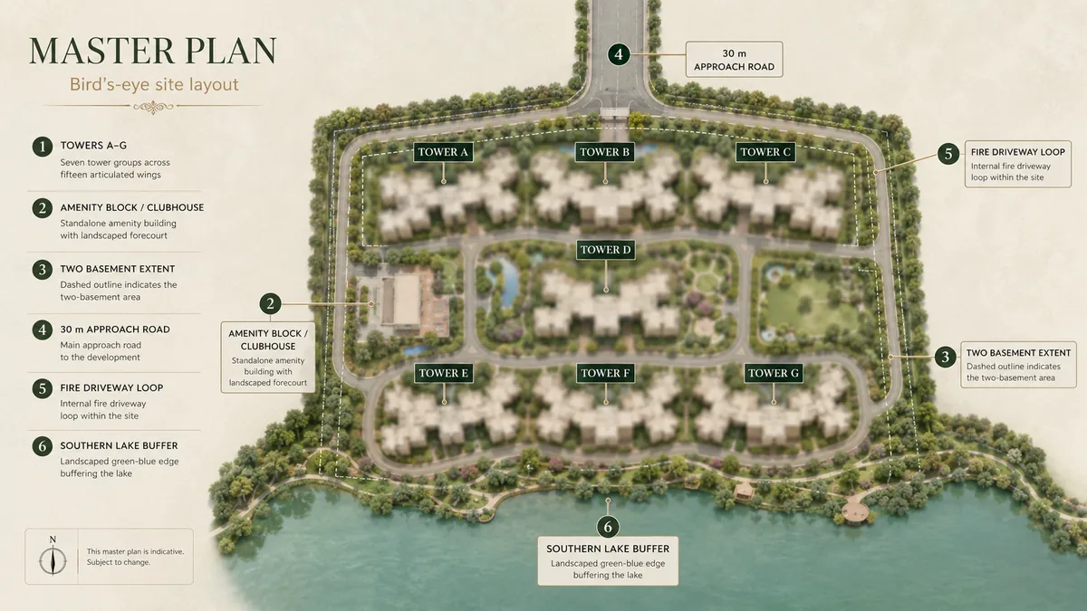
SNN Sarjapur Road master plan showing towers A to G across fifteen wings, the standalone amenity block, the two-basement extent, the 30 m approach road, the internal fire driveway loop and the southern Hosa Lake buffer

Master Plan — SNN Sarjapur Road

The SNN Sarjapur Road Master Plan Land-Use Schedule

Land useArea (sq m)Area (acres)Share
Development area1,21,758.7730.09100%
Landscape49,829.2812.3140.9%
Driveway32,661.648.0726.9%
Ground coverage (buildings)16,056.443.9713.19%
Park and open space12,175.883.0110.00%
Civic amenities6,339.561.575.21%
Services4,695.971.163.85%

Two things are worth noting before the analysis. First, the six line items add to 1,21,758.77 sq m exactly — the table closes on its own development area, which is a basic internal-consistency check that a surprising number of published master plans fail.

Second, the development area of 12.1759 hectares works out to roughly 30.09 acres, and it sits between the two land extents on file: 30.66 acres in the project information sheet and 28.74 acres (11.6321 ha) in the Common Application Form. That discrepancy is unreconciled in the source documents and is disclosed here once. The land-use table is the internally consistent document, so the ratios below are computed against its own development area rather than either headline acreage.

Low Density Apartments Bangalore Buyers Can Verify: Reading the 13.19% Ground Coverage

Ground coverage is the single number that separates a genuinely low-footprint scheme from a marketing claim, because it cannot be dressed up. It is the share of the site the buildings physically stand on, and at 13.19% it means roughly 3.97 acres of building footprint across 30.09 acres.

The trade-off that number buys is open ground, and it is buying a lot of it:

  • Landscape and park together come to 62,005.16 sq m — 15.32 acres, or 50.9% of the development area. More than half the site is soft ground.
  • Driveway takes 26.9%, which sounds heavy until you see what it carries (below).
  • The building footprint is only the third-largest line item on the schedule, behind landscape and driveway. Park and open space, civic amenities and services all sit below it.

The price of low coverage is height, and the plan pays it openly. With a FAR of 3.26 applied to the development area, the sanctionable floor area is roughly 3,96,900 sq m. Divide that by the 16,056.44 sq m footprint and you get about 24.7 — which is, almost exactly, the Ground + 24 upper floors the towers are designed to. The scheme stacks its footprint twenty-five times because that is the only way to house a project of this size on four acres of ground. Total built-up area, including the non-FAR basements, is 5,52,042.27 sq m.

Park and open space lands on 10.00% to the second decimal — 12,175.88 sq m is precisely one tenth of 1,21,758.77. That precision is the signature of a statutory minimum met exactly, not a design decision. The 40.9% landscape allocation is the design decision, and it is the one that is four times any reservation requirement.

For context on why this matters in this micro-market: the branded competing supply within a couple of kilometres is small-format. A 1.7-acre single-tower scheme like Purva Heritage at Kudlu Gate cannot produce a 50% soft-ground ratio at any density, because its setbacks, driveway and fire access consume the site before landscape gets a turn. Ground-plane generosity is a function of parcel size, and parcel size is what this plan actually sells.

What the Revision Changed

The earlier plan on record and the Revised ToR are two different schemes on the same land. The direction of travel is unusual and worth reading carefully.

ParameterEarlier planRevised ToRChange
Built-up area6,20,175.64 sq m5,52,042.27 sq m−68,133 sq m (−11.0%)
FAR3.9983.26−18.5%
Ground coverage18.86%13.19%−5.67 percentage points
Water demand1,948 KLD1,740 KLD−10.7%
STP capacity1,160+700+20 KLD900+700+20 KLD−13.8%
Car parking5,2184,900−318 bays

Applied to the same 1,21,758.77 sq m development area, the coverage reduction alone hands back about 6,907 sq m — roughly 1.7 acres — from building footprint to open ground. Projects usually get denser between filings, not lighter. This one moved the other way on every measured axis. When the sanctioned plan and the RERA registration eventually land, the ground coverage figure is the first line to check for reversion.

Tower Placement: Seven Towers, Fifteen Wings, One Standalone Amenity Block

The plan is organised as seven towers lettered A to G, subdivided into fifteen wings, plus a separate amenity structure. Towers run 2 Basement + Ground + 24 upper floors at 79.95 m; the amenity block is Basement + Ground + 3 floors at 21 m.

Fifteen wings across seven letters means the towers are not uniform — some carry a single wing, others two or three. The roof rainwater sump schedule (further down) is independent evidence of this: sump volumes range from 46 to 272 cubic metres, a nearly sixfold spread that can only reflect very different roof plate areas.

Some useful arithmetic on the wing plates, using the total unit count range on file (2,075+ per one document, 2,359 per another — both provisional):

  • 16,056.44 sq m of footprint across fifteen wings and the amenity block gives an average plate near 1,000 sq m.
  • 2,075 to 2,359 homes across fifteen wings is 138 to 157 homes per wing, or roughly six homes per floor per wing over 24 upper floors.

Six units on a thousand-square-metre plate is a slim, efficient tower rather than a wide slab. It is the configuration that produces cross-ventilation and corner units on most floors, and it is the direct structural consequence of choosing 13.19% coverage. Treat both unit counts as provisional until the sanctioned plan is on the record.

The amenity block being a separate structure is a deliberate choice, not an accident of layout. Clubhouses inserted into the podium levels of a residential tower push plant noise, party noise and late-hour footfall into the same structure as the homes above them. A standalone Basement + Ground + 3 building isolates all of that, gets its own arrival point and its own basement, and — at 21 m against the towers' 79.95 m — sits well below the tower line, so it blocks neither the southern sightlines nor the maturing tree canopy.

The 79.95 m tower height is itself a designed number. It sits fractionally below 80 m, and heights in that band are set with an eye on the approval and fire-compliance thresholds that apply above them.

The Southern Lake Frontage and How the Layout Orients to It

The southern boundary faces Hosa Lake — also called Kudlu Lake, and recorded in mapping data as Hosakere. The nearest lake boundary is about 0.15 km straight-line from the site pin, which places the water directly off the southern edge rather than somewhere in the middle distance.

This is the axis the whole layout is organised around, and the reasoning is straightforward:

  • Southern frontage is the only edge with an open horizon. On three sides the plan looks at its own buffer and whatever develops beyond it. On the fourth, the sightline runs out over open water and does not come back.
  • Height plus low coverage is what makes a lake view a lot of lake views. A 24-storey wing oriented south delivers the outlook to every floor above the tree line, not only to a premium top-floor tier. Slim plates mean more of each floor's homes get the orientation.
  • The 40.9% landscape allocation gives the southern edge room for a real buffer rather than a token strip — a graded transition from the buildings through planting to the boundary.
  • The lake carries a public walking track described at roughly two kilometres, and its water and tree cover support resident birdlife. Both sit immediately outside the southern boundary, which means residents get the amenity without the site having to maintain it.

Lake-facing stock in Bengaluru consistently commands a premium over identical inward-facing units in the same tower. On a plan with this much southern edge, that premium tier is likely to be a large share of the inventory rather than a handful of units.

Nala Buffers on Three Edges — and an Unresolved 5 Metres

A nala runs along the northern, western and eastern boundaries. Combined with the lake to the south, the parcel is hydrologically bounded on all four sides. That single fact explains much of the rest of the plan: the low coverage, the buffer emphasis, the 41 recharge pits and the perimeter green belt that the buffers effectively force into existence.

The buffer widths are not settled in the source documents, and this is the most consequential open item on the page:

BufferToR narrativeSite-plan drawing
Lake (southern edge)24 m30 m
Nala (north, west, east)10 m15 m

The gap is 6 m on the lake and 5 m on each nala edge, and it is real land. On an illustrative 350 m × 350 m parcel — close to the recorded development area — three nala edges at 15 m instead of 10 m is about 5,250 sq m (1.3 acres) of additional reserved strip, and the lake edge at 30 m instead of 24 m adds roughly 2,100 sq m more. Taken together the two readings differ by something on the order of 1.8 acres of buildable versus reserved ground.

Which figure governs matters to a buyer in two ways: it changes how close the nearest tower can stand to the water, and it changes the effective perimeter green belt. The drawing is the wider of the two. Ask for the sanctioned plan and hold the buffer to whatever it records.

Approach, Internal Circulation, Fire Driveway and Walking Routes

The site is entered from a 30 m approach road — a wide feeder by the standards of this pocket, and one of the more important line items on the plan, because a project of 2,000-plus homes generating peak-hour vehicle movements onto a narrow lane is a well-documented failure mode in South Bengaluru.

Internally, the 26.9% driveway allocation (32,661.64 sq m, 8.07 acres) looks large until you account for what it has to do:

  • Fire tender access to every one of fifteen wing entrances plus the amenity block. At 79.95 m these are high-rise structures, which requires a continuous, load-bearing hard-standing loop with turning room at each tower — not decorative paving.
  • Basement ramps down to two levels holding 4,900 cars, sized for two-way movement at peak.
  • Service and refuse access to the service block and every wing's waste room, on a route that does not run through resident areas.
  • Visitor and drop-off circulation at the arrival points.

The consequence for residents is the more interesting half. Because parking is buried across two basements, the resident who arrives by car goes basement to lobby to home and never crosses the fire driveway at grade. That decouples pedestrian movement from vehicle movement almost entirely, and it is what makes 12.31 acres of landscape usable rather than ornamental. Walking routes can run through the planting and the park allocation, connect the wings to the amenity block, and reach the southern edge without a road crossing. On a site where the driveway is a quarter of the ground, keeping people off it is the whole design problem — and burying the parking is the answer.

The 2,300-Tree Planting Programme

The plan commits to 2,300 trees across twelve named species. Scaled against the site, that is roughly 76 trees per acre, one tree for every 21.7 sq m of landscape area, and — on the unit counts on file — very close to one tree per apartment.

SpeciesCharacterRole on this site
Neem (Azadirachta indica)Native, drought-hardy, denseYear-round shade, low water once established
Kadamba (Neolamarckia cadamba)Native, fast-growing, large crownEarly canopy while slower species mature
Arjun (Terminalia arjuna)Native, riparian, deep-rootedWell suited to the nala buffer edges
Jamun (Syzygium cumini)Native, fruiting, largeBird forage; links the site to the lake edge
Bael / Bilvapatre (Aegle marmelos)Native, fruitingListed under both its names
Devil's Tree (Alstonia scholaris)Native, fast, tall and columnarScreening along narrow buffer strips
AsokaEvergreen, uprightEdge and avenue planting
Nagalinga Pushpa (Couroupita guianensis)Large, distinctive floweringFeature planting at arrival and amenity points
ChampaFragrant floweringCourtyard and walkway scale
Gulmohur (Delonix regia)Flowering, wide crownDriveway shade; Bengaluru avenue staple
Jacaranda (Jacaranda mimosifolia)Flowering, light canopySeasonal colour along internal routes

Eleven rows for twelve names, and the reason is worth stating: Bilvapatre is the Kannada name for Bael, so the twelve-name schedule resolves to eleven distinct trees. That is a documentation artefact, not a shortfall in the planting count. Note also the balance of the palette — the large-crowned natives (Neem, Kadamba, Arjun, Jamun, Bael, Devil's Tree) carry the structural canopy, while Gulmohur, Jacaranda, Champa and Nagalinga Pushpa are the flowering layer that does the visual work in years one to five.

What a canopy palette does over twenty years is different in kind from what an ornamental one does. A scheme built on palms, bottlebrush and clipped shrubs looks finished on handover day and looks the same in 2046. A palette anchored on Neem, Kadamba, Arjun and Jamun looks thin at handover and becomes a microclimate: large-crowned natives shading the 8 acres of driveway and cutting the hard-surface heat that drives afternoon cooling loads; deep root systems holding the nala buffer edges against monsoon scour; fruiting species creating a continuous bird corridor between the planting and the lake; and leaf litter and shade reducing irrigation demand on the landscape year after year.

The corresponding trade-off is patience and enforcement. Two thousand three hundred saplings are a promise, and planting schedules are a common casualty of value engineering between filing and handover. Two things to verify: that the species mix in the sanctioned landscape drawing still carries the large natives rather than substituting fast ornamentals, and that the maintenance obligation for the first three to five years — the period that decides whether a sapling becomes a tree — is written into the association handover.

Two Basements: Where the Plan Hides Its Machinery

Everything that makes 13.19% ground coverage possible is buried. The two basement levels carry, at minimum:

  • 4,900 car bays — roughly two per home against either unit count on file, which is generous for the configuration mix and effectively removes surface parking from the design problem.
  • Water storage: 9,75,000 litres of raw water in sumps, plus fire storage.
  • Plant rooms: pumping, hydro-pneumatic sets, fire pumps, transformer and HT rooms against a 9,170 kW BESCOM sanctioned load, and diesel generator rooms for 10 × 500 KVA of standby.
  • Vertical service cores connecting to every wing lobby.

Two basements rather than three is worth stating plainly, because generic payment and specification templates circulating for projects of this type routinely reference three. This plan is 2B + G + 24.

The Sustainability Plant, in Numbers

SystemProvision
Water demand1,740 KLD (1,156 fresh + 585 flushing)
Wastewater generated1,566 KLD
Sewage treatmentSBR STP, 900 + 700 + 20 KLD (1,620 KLD total)
Treated water available1,488 KLD
Groundwater recharge41 recharge pits
Roof rainwater sumps272 / 240 / 116 / 185 / 72 / 46 / 91 cu m (1,022 cu m total)
Raw water storage9,75,000 litres
Overhead tank1,00,000 litres
SolarProposed
Solid waste5,276 kg/day (2,110 bio / 3,166 non-bio)

The STP split is the smartest line in the schedule. Sequencing batch reactor plant handles the swinging diurnal load a residential project produces better than a continuous-flow system, and splitting capacity into 900 and 700 KLD modules rather than one 1,620 KLD unit means either module can be taken offline for maintenance while the other carries base load. That matters, because total capacity of 1,620 KLD against 1,566 KLD of generation is only about 3.4% headroom — thin enough that a single-train plant taken down for servicing would have nowhere to send the flow. The modularity is what protects the margin. The 20 KLD unit is a small separate stream, most plausibly serving the amenity block.

The roof harvesting reserve is larger than most buyers would guess. Seven sumps, one per tower, totalling 1,022 cubic metres — which is more than the 975 cubic metres of raw water storage. The site therefore holds roughly as much captured rainwater as it does bought water. The spread across the seven (46 cu m at the smallest, 272 at the largest, a 5.9× range) tracks roof plate area and independently confirms that towers A to G differ substantially in size.

Recharge is where the low coverage pays off again. Forty-one pits distributed across 62,005 sq m of soft ground is about one pit per 1,512 sq m of permeable surface. A site at 13.19% coverage with half its area unpaved can actually infiltrate rainfall rather than shed it into the nala — which is the difference between a development that loads the drainage network on the northern, western and eastern edges and one that relieves it.

On stored water, one honest caveat: 9,75,000 litres of raw storage plus a 1,00,000 litre overhead tank is about 0.9 days of the 1,156 KLD fresh-water demand. That is standard for BWSSB-connected projects and it is not a defect, but it does mean the recharge pits, the rainwater sumps and the 1,488 KLD of treated water going back into flushing and landscape are load-bearing parts of the water strategy rather than decorative ones.

What to Verify Before You Commit

This is a pre-launch. The land-use schedule is drawn from a statutory filing that is under examination, not from a sanctioned plan, and Karnataka RERA registration has not been granted. Five items to hold the developer to when it is:

  1. Ground coverage stays at 13.19% in the sanctioned plan — this is the number the whole low-density case rests on.
  2. The buffers, resolved to the site-plan drawing's 30 m lake and 15 m nala rather than the narrative's 24 m and 10 m.
  3. Land extent and unit count, reconciled between the 30.66-acre / 2,075-unit and 28.74-acre / 2,359-unit readings.
  4. The landscape drawing's species schedule, confirming the large natives survived into the planting contract, with a written maintenance period.
  5. Basement count and parking ratio — 2B and 4,900 bays, against any template document that says otherwise.

For a sense of how this developer executes a large-format plan once it is out of the ground, the group's SNN Electronic City project is a useful comparison point on the same metro corridor.

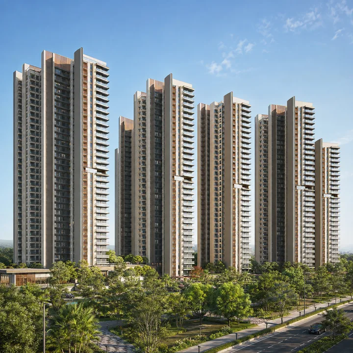
SNN Sarjapur Road residential towers rising 2B+G+24 to 79.95 m above landscaped open space at Kudlu, off Sarjapur Road, Bengaluru

Enquire about SNN Sarjapur Road

Request the brochure, the current cost sheet, floor plates and a site visit for SNN Sarjapur Road.

Enquire Now

SNN Sarjapur Road Master Plan - Frequently Asked Questions

The revised ToR provides for 4,900 car parking spaces, trimmed from 5,218 in the earlier plan, across two basement levels. Against a unit count of 2,075 to 2,359 that works out to roughly two spaces per apartment before visitor allocation, which is comfortably above the norm for high-rise stock in this belt. Parking ratio is worth confirming per configuration at booking, because allocation between 2 BHK and 4 BHK units is rarely uniform. The two-basement format also matters for the surface plan: it is what keeps 40.9% of the site under landscape.

Water is drawn from BWSSB at a total demand of 1,740 KLD, split as 1,156 KLD fresh and 585 KLD flushing — again reduced from 1,948 KLD in the earlier plan. Wastewater generation is 1,566 KLD, treated in an SBR sewage treatment plant configured at 900 + 700 + 20 KLD, yielding 1,488 KLD of treated water for flushing, landscape and construction reuse. Raw water storage is 975,000 litres with a further 100,000 litres overhead, and 41 recharge pits are proposed. Power is 9,170 kW from BESCOM with ten 500 KVA diesel generators for backup and solar proposed.

Yes — the lake runs along the southern boundary of the site, roughly 0.15 km from the pin, which gives the southern edge of the development genuine water frontage and an open horizon that a landlocked infill site cannot replicate. It is variously called Hosakere and Kudlu Lake, and its recorded size differs by source between about 32 and 45 acres, so treat the acreage as unsettled. It carries a walking track of roughly 2 km, with resident birdlife along the water's edge. The statutory buffer to the lake is one of the open items: the ToR narrative specifies 24 m to the lake and 10 m to the nala, while the site-plan drawing shows 30 m and 15 m.

The residential towers are planned at two basements plus ground plus 24 upper floors, to a height of 79.95 m, with a lower amenity block at basement plus ground plus three floors, 21 m tall. Against the revised ToR the FAR is 3.26 on a built-up area of 5,52,042.27 sq m — down from an earlier plan at FAR 3.998 and 6,20,175.64 sq m, so always read the revised figures. Ground coverage is 13.19%, which is what allows 24-storey towers and still leaves the ground largely open. Of a development area of 1,21,758.77 sq m, landscape takes 49,829.28 sq m or 40.9%, driveways 26.9%, and park and open space a further 10.00%, with civic amenities at 5.21% and services at 3.85%. The planting schedule specifies 2,300 trees across twelve species including Kadamba, Neem, Gulmohur, Jacaranda, Bilvapatre, Arjun and Jamun — a green-cover profile no small-format tower in Kudlu Gate can match.

Two figures appear in the documents and they do not reconcile: the project information sheet states 30.66 acres, while the environmental CAF states 11.6321 hectares, which converts to 28.74 acres. We publish both rather than picking the flattering one. The difference is roughly 1.9 acres, which is the kind of gap that usually resolves as gross versus net developable area once the final approved plan is issued. Either way this is a 28–31 acre parcel, placing it in the large-format class alongside Prestige Southern Star and Sobha Townpark.

The site sits at Kudlu, off the Sarjapur Road and Haralur Road belt in south-east Bengaluru, PIN 560068, on the pin 12.8880056, 77.6649778. It lies behind the completed SNN Raj Etternia development, east of Hosur Road, with Hosa Lake running along its southern boundary roughly 0.15 km away as the crow flies. The address is best understood as the Kudlu Gate–Hosa Road pocket rather than Electronic City, which is a commute destination from here, not the location. Parappana Agrahara is the revenue village name that appears on some documents.